



Background
The Comprehensive Peace Agreement of 2005 between the Government of Sudan (GoS) and the Sudan People’s Liberation Movement (SPLM) includes a separate protocol on the resolution of the Abyei conflict. These highlights will therefore provide details on the geographical contentions along the four compass borderlines between Kordofan and Bhar el Ghazal region.
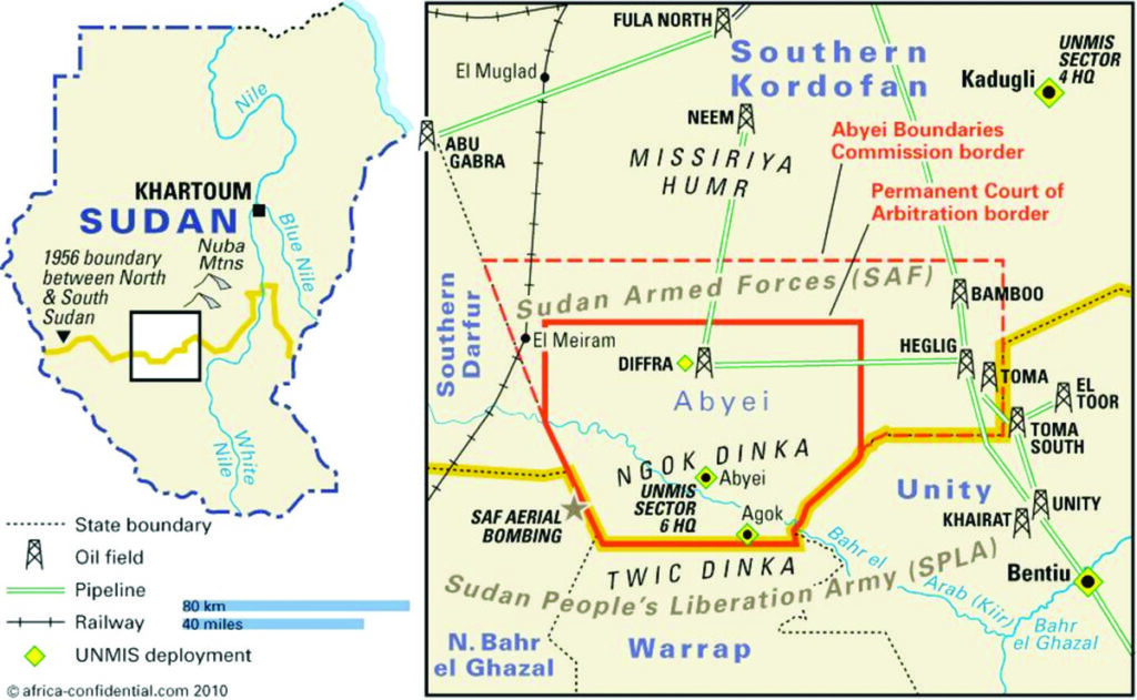
Each of these institutions mentioned above have their positions on the borderline between Kordofan and Bhar el Ghazal, which was contested by both parties, the GoS and the SPLM, and the matter was referred for arbitration proceedings and finally determined and awarded by the Permanent Court of Arbitration on 22 July 2009.
At the outset, Article 5.1 of the Abyei Protocol established the Abyei Boundaries Commission (ABC) with a mandate to define and demarcate the area of the nine Ngok Dinka Chiefdoms transferred to Kordofan in 1905, known as the Abyei Area, and to subsequently submit the final report to the Presidency within two years of the interim period to allow the Presidency to put the special administrative status of Abyei Area into immediate effect. After the completion of the work by the ABC, the report was submitted to the Presidency on 14 July 2005, five days after the deadline set by the Abyei Protocol.
Geographical points of contention
After submission of the ABC report, it was contested by both parties: The GoS and the SPLM on the demarcation and delimitation of the Abyei Area. There were two different interpretations of the report: The GoS said what has been submitted by the ABC must be considered as opinions and recommendations, which would be studied because the ABC exceed their mandate by focusing much more on consultations with dominant members of the Ngok Dinka in the Abyei Area instead of other communities in the surrounding areas, amongst other violations of the ABC mandate.
On the other hand, the members of the Ngok Dinka in the SPLM Delegation said what has been submitted is a final and binding decision, which must be implemented. This is how the disagreement between the parties over the ABC report came about. The parties therefore, as explained herein, agreed to refer the matter for arbitration.
In the comparative submission of the parties’ position on thematic issue number three on “the relevance of the Kordofan/Bahr el Ghazal boundary to the delimitation of the area transferred in 1905, the Permanent Court of Arbitration (PCA) posed a question in paragraph 269 (3) (a) of the Arbitral award: “whether did Bahr el Arab (Kiir River) constituted a precise and proclaimed provincial boundary between Kordofan and Bahr el Ghazal and the northern limit of the area transferred in 1905?
In answering this question, the GoS answered the question during the oral pleadings by acknowledging the existence of Bahr Al Arab (Kiir River) as a borderline between Kordofan and Bahr El Ghazal. In their exact submission as reflected in paragraph 270 of the PCA arbitral award, “the GoS argues that the Condominium administration was present in the Abyei region and explored the area before and in 1905. Despite limited and short-lived uncertainty surrounding the location of the Bahr el Arab, it is clear that there was a precise boundary between Kordofan and Bahr el Ghazal on that river before the transfer and that the highest-ranking official, who knew where the Bahr el Arab was, considered it to be both the provincial boundary and the northern limit of the transferred area in 1905”.
In addition, the GoS submits that several pre-1905 documents describe the Bahr el Arab (Kiir River) as the provincial boundary between Bahr el Ghazal and Kordofan, including: Frank Lupton’s 1884 writings; and 1884 report by the Intelligence Branch of the War Office; the 1898 first edition of the 1898 Gleichen Handbook; Mardon’s 1903 revised map (first issued in 1901); the 1902 to 1904 Bahr el Ghazal Annual Reports; the 1904 Kordofan Annual Report (which states that “the Darfur Frontier […] runs southwards, west of Dar Homr to the Bahr el-Arab which is the northern boundary of the Bahr el-Ghazal Province”); the 1905 Bahr el Ghazal Annual Report (which no longer refers to the provincial boundaries as being “vaguely defined”); and the 1905 Gleichen
In contrast, the SPLM, dominantly represented by members of the Ngok Dinka community during the oral pleadings before the PCA in The Hague, the Netherlands, in 2009, “contends that in 1905, there was virtually no administration in Southern Kordofan and Bhar el Ghazal; and that there was widespread and prolonged confusion as to the location of the Bhar el Arab (Kiir river). Contrary to the GoS position, the provincial boundary between Kordofan and Bhar el Ghazal was indefinite in 1905 and irrelevant to a transfer that concerned a people as opposed to a specific area”. Unfortunately, such an assertion was viewed and observed clearly as the position of the Ngok ethnic community in the name of the SPLM.
Arbitration agreement and scope of dispute
In the arbitration agreement between the GoS and the SPLM signed on the 7th of July 2008 in Khartoum, the scope of dispute arises as follows:
- Whether or not the ABC experts had, based on the agreement of the Parties as per the CPA, exceeded their mandate, which is “to define (i.e. delimit) and demarcate the area of the nine Ngok Dinka chiefdoms transferred to Kordofan in 1905” as stated in the Abyei Protocol, and reiterated in the Abyei Appendix and the ABC Terms of Reference and Rules of Procedure
- If the Tribunal determines, pursuant to Sub-article (a) above, that the ABC experts did not exceed their mandate, it shall make a declaration to that effect and issue an award for the full and immediate implementation of the ABC Report.
- If the Tribunal determines, pursuant to Sub-article (a) herein, that the ABC experts exceeded their mandate, it shall make a declaration to that effect, and shall proceed to define (i.e. delimit) on map the boundaries of the area of the nine Ngok Dinka chiefdoms transferred to Kordofan in 1905, based on the submissions of the Parties.
Accordingly, the GoS argued “that the ABC Experts have exceeded their mandate as stated in the Abyei Protocol, and reiterated in the Abyei Appendix and the ABC Terms of Reference and Rules of Procedure while on the other hand, the SPLM represented by sons and daughters of Ngok dinka argued that “the ABC Experts did not exceed their mandate based on the agreement of the parties as per the CPA, which is “to define (i.e. delimit) and demarcate the area of the nine Ngok Dinka chiefdoms transferred to Kordofan in 1905” as stated in the Abyei Protocol, and reiterated in the Abyei Annex and the ABC Terms of Reference and Rules of Procedure.
ABC report and arbitration tribunal award
As a result, the matter was referred to the Permanent Court of Arbitration for determination. In the course of deliberations and submission of the parties, the Arbitration Tribunal determined the demarcation and delimitation of the Eastern, Northern and Western boundaries where the ABC have exceeded their mandate in some areas and did not exceed their mandate in others, as explained in the attached paragraphs 286 through 773 of the arbitral award.
However, on the Southern Boundary of the Abyei area, paragraph 698 of the Arbitration award provides that “the southern boundary shall be the Kordofan Bahr el-Ghazal-Upper Nile boundary as it was defined on 1 January 1956.” The southern boundary of the Abyei Area was clearly not the focus of dispute between the parties over the course of the ABC proceedings. Having reviewed the evidence, the ABC Experts adopted this boundary as the southern limit of the area of the nine Ngok Dinka chiefdoms transferred in 1905. There is no submission that this conclusion exceeded the mandate and indeed, it does not.
Additionally, paragraph 699 of the arbitration award confirmed that “the Arbitration Tribunal recalls that the southern boundary of the Abyei Area remained uncontroversial in these proceedings. As provided in the GoS Counter-Memorial: Both parties accept that the 1956 provincial boundary, which continues to be the boundary today, constitutes the southern limit of the area transferred in 1905. There is accordingly no dispute on this aspect of the case”.
In light of these backgrounds and findings, the focus of this brief is to clear the doubt that the boundary between Kordofan and Bhar el Ghazal is the Bhar el Arab (Kiir River) as stated by the GoS, before the transfer of the Abyei area in 1905 and as it stand on the 1st January 1956, which was also reported by the ABC Experts, and finally confirmed in the arbitration tribunal award in paragraphs 770 to 773, respectively.
In particular, paragraph 770 (b) of the arbitration award on the southern boundary of the Abyei area, in respect of the ABC Experts’ decision that “[t]he southern boundary shall be the Kordofan – Bahr el-Ghazal – Upper Nile boundary as it was defined on 1 January 1956,” the ABC Experts did not exceed their mandate. The southern boundary as established by the ABC Experts is therefore confirmed.
The writer is a researcher on politics and governance and can be reached via hakimchol@gmail.com.
The views expressed in ‘opinion’ articles published by Radio Tamazuj are solely those of the writer. The veracity of any claims made is the responsibility of the author, not Radio Tamazuj.

 and then