


Social media platforms have recently been awash with hate speech stemming from Ethiopia’s claim over Raat, along the border with South Sudan.
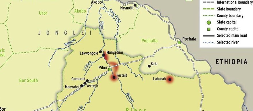
The area has been contested by both the Anyuak and the sedentary farming Murle community, also known as the Ngalam or the Jebel Boma Murle. For a century, the Anyuak, the Jie, the Murle, and the Kachipo have coexisted peacefully in what is now referred to as the Greater Pibor Administrative Area’s (GPAA) Jebel Boma County. The Anyuak lived harmoniously with the Ngalam Murle in Awetaballa until recently.
The history of Awetabala/Jebel Boma/Raat can be traced back to the arrival of three Anyuak brothers: Okwa, Apinydide, and Gak. The brothers were the first settlers in the Boma and are the ancestors of the Okwa/Boma Anyuak, a Luo group of Eastern Nilotes. They arrived in the area from Lafon/Bahr el-Ghazal around the 15th century.
The Lafon group settled at Boma Mountain, along a stream called Awang’ Nyang’, now referred to as Labarab in the Murle dialect. At Awang’ Nyang’, a dispute arose among the three brothers, leading Okwa and Apinydide to establish a village on the northwestern side of Boma Mountain, while the Jie settled to the southwest. Gak traveled north of Awang’ Nyang’ to the Ojwaa, where he established a village now known as Jo Ojwaa (Ojwaa people).
Okwa and Apinydide remained around Boma Mountain, but faced challenges when their cattle died due to tsetse flies. Consequently, they decided to migrate to Pool Dwai near the Nyibari River, then to Aguma Mountains, and finally to Aweta-Bala stream near Alal Mountains, today referred to as Khor-Chum, Pakok, and Suri.
Robert Collins writes that the most powerful local authority in the borderlands was Olimi, after whom the Ilemi Triangle was named. Olimi, whose name the British misspelled as Illemi, was a prominent Anglo-Egyptian Sudanese Anyuak king during the 20th century. His village was the last Anyuak settlement along the Akobo River, near its junction with the Ajibur River, bordering both Ethiopia and the protectorate of Uganda. Olimi was so respected that the government honored him before his assassination in 1936. While his territory extended to Illemi, Boma was his home and the base from which he ruled, and it was in Boma that he was laid to rest.
According to Manas J. Okony, the Boma, home to the Murle, the Anyuak, the Jie, and the Kachipo, has a name derived from the Anyuak word Biem, meaning guerrilla, reflecting the area’s significant guerrilla population. Another interpretation suggests that the name comes from Bomo, meaning; let us branch, coined by the Lafon group who viewed the mountainous terrain as a barrier during their march.
In the early 20th century, the Kachipo migrated to the Boma plateau during a severe drought in the Ethiopian highlands. Chief Losanga reached an agreement with the Boma Murle to live and cultivate near Mount Bejunu. By this time, the Murle had already established themselves in their current territories, having begun settling there by the 1850s.
During the colonial era, the Boma region witnessed intermittent conflicts involving the Anyuak, the Murle, and the Kachipo. However, these conflicts were typically resolved quickly. Notable instances include the 1932-34 Anyuak raid on the Murle and a 1936 combined alliance of the Anyuak and Murle against the Kachipo. Both colonial and traditional authorities played roles in resolving the disputes, reflecting a spirit of coexistence.
Since the era of King Olimi, there has been a consistent effort to promote lasting peace in the area. For example, in the 1920s, a treaty was established between the Okwa/Boma Anyuak and the Murle of Jebel Boma under the king, aimed at keeping the border between the two communities free from conflicts. The oral treaty, respected by the Boma communities, stipulates that if either the Anyuak or the Murle resorted to violence, they would suffer severe consequences. Due to the oral agreement, Jebel Boma enjoyed peace from the 1920s until 1984, when the Murle abducted children from Okwa and killed civilians.
It is important to acknowledge that the Boma Murle do not have a historical border with the Akobo River. Raat, the South Sudanese army post on the Akobo Riverbank, belongs to the Okwa community of the Anyuak, from whom the Murle were claiming ownership.
The term “Ngalam” refers to the Olam. Several years ago, some individuals from the Olam tribe migrated from the Ethiopian highlands to the southern Boma Mountains, which are now referred to as Ngalam, meaning Olam (tribe) people. These newcomers were not originally from the Murle, who migrated from Torit (Chukudum) in the Boya Mountains during the mid-19th century. However, they share a closely related language.
The Ngalam people settled south of the Boma highlands and formed positive relationships with the Okwa Anyuak, both in the mountains and across the river. This coexistence is exemplified by the alliances between the two communities. For instance, during the last century, when the Kachipo tribe attacked the Ngalam area, the Ngalam sought refuge in the Okwa territory. The Okwa people stood by them, defending the displaced tribe, and together with the Anyuak forces, chased the Kachipo away from the Boma Mountains, allowing the Ngalam to return to their village. Through this struggle, they forged a brotherhood, sharing experiences of hardship.
The border between the Anyuak and the Ngalam lies at the Aligam Mountain/Nyilangora, near a stream called Pool Dwai, between Ngalangora and Aguma Mountain. The communities of Boma are closely interconnected by lineage, which should serve as a foundation for peaceful coexistence.
One of King Kwot Olimi’s sons, whose mother was of the Murle descent, Mazee, has been the head chief of Nyat since 1992. In the time of King Okwanga Kwot Olimi, Lakurnyang Lado approached him seeking to establish an Anyanya-2 camp. King Okwanga directed them to the Raad camp in 1983.
Okwanga succeeded his father, Olimi Kwot, as king of Okwa in 1978 until the outbreak of war in southern Sudan. He joined the Anyanya-II movement and later the SPLM/A rebellion at Bilpam in 1983, where he rose to the rank of captain.
In early 1983, King Okwanga granted permission for the breakaway Anyanya-II faction, led by Lakurnyang Lado, to establish a base at Raat. This marked the first settlement of non-Anyuak people in Raat. The land of Okwa/Raat provided sanctuary and resources, including gold, fish, and wild meat, to freedom fighters. According to the Anywaa customs, every piece of land belongs to a specific clan, and its use must follow proper channels. Commander Lakurnyang Lado, who was detained and publicly executed by his colleagues, adhered to these processes and was granted Raat as his training camp.
After the collapse of Lakurnyang’s rebellion, Raat was abandoned but was reoccupied in 1985 when the Scorpion (Agrab) battalion, under the command of Ngachigak Nyachuluk, graduated from the Bonga training camp and headed to liberate Jebel Boma. Their forces resettled in Raat. It is essential to note that Raat does not belong to the Murle people; all SPLA/M high commanders are aware that this area belongs to the Anywaa community. Thus, SPLM/A commanders consistently sought the king’s blessing before launching military campaigns.
In 1985, King Okwanga was asked by Commander Nyachigak to offer a blessing, known as “Lam” in Anyuak, meaning prayers, early in the morning for the land and the forces accompanying him into battle. That year, Boma Garrison was captured by the Agrab battalion.
In 1991, following the military overthrow of Ethiopia’s Mengistu Hailemariam’s government, Raat was renamed Pakok by the Dinka people fleeing from Ethiopia. Some members of the Red Army may remember this name, and in 1992, Sudanese refugees from the Dima camp and SPLA/M forces returned to Sudan, referring to the area as Pakok. This name was used as a code during the movement to avoid bombing by the Sudanese government during the war.
The long civil war ended with the Comprehensive Peace Agreement (CPA) on January 9, 2005. During this period, the area became known as Suri Payam. The Ngalam Murle took the payam of Awetabala to their part of Jebel Boma County, naming it Suri Payam (meaning hunting in Murle).
In 2008, the area experienced brief ups and downs during the census, but the issues were resolved.
The Anyuak community shares a blood relationship with the Boma Murle. Boma Payam falls under Pibor County, while the Awetabala/Raat/Pakok area has been under the Pochalla County Administration since 1976, when Pochalla was upgraded to a district. Before 1976, both Pochalla and Boma fell under the Pibor District. The dispute between the Anyuak of Okwa and the Murle of Boma has been discouraged by the elders from both sides.
The Awetaballa Anyuak are committed to coexisting peacefully with the Ngalam Murle, free from prejudice and segregation in Awetaballa. The CPA grants all South Sudanese nationalities the right to exist and develop their own cultures within the borders established in 1956.
The internally displaced persons (IDPs) and refugees from all South Sudanese nationalities are returning to their original homelands to rebuild their lives. The Anyuak of Awetaballa also wish to return to their original homeland.
Othow Okoti is the commissioner of Pochalla South County in the Greater Pibor Administrative Area (GPAA). He was also the founding station manager at Radio Pochalla FM.
The views expressed in ‘opinion’ articles published by Radio Tamazuj are solely those of the writer. The veracity of any claims made is the responsibility of the author, not Radio Tamazuj.
 and then