


Introduction
Following the decision by the “Presidency” on February 15, 2020, to suspend the current administrative structure of 32 states with the view to reverting to former ten states plus three administrative areas until such time as the referendum is held as stipulated in the 2018 Agreement, one would have expected a well-intentioned opposition to appreciate the significance of the concession that the Government has made, even when such a painful decision was undertaken in violation of the peace Agreement. I say “violation” because that is effectively what this Presidency’s decision has done, having regard to the fact that the decision falls outside the ambit of the modality of resolving the issue of the number of states pursuant to the 2018 Agreement. The decision also ultra vires the powers of the President and is, therefore, unconstitutional. That is because the President does not have the competence, under the Transitional Constitution, to change the number of states without the approval of the Republican (so-called National) Legislature. But that is a subject for another day.
Yet instead of reciprocating the spirit of goodwill, compromise and conciliatory tone set by the President, some opposition parties responded by claiming that (a) the decision did not go far enough; (b) rejected the decision outright; or (c) responded in jest and satire, practically mocking the President. In this mix, two rebel groups, namely Riek’s SPLM-IO and Lam Akol’s NDM singled out Ruweng and other administrative areas. But the force with which they rejected Ruweng was unique.
One thing, however, should be made clear. The underlying motivation for these two armed rebel groups’ concerted efforts to target Ruweng may surely elude those who do not have fundamental grasps of the South Sudanese political and internal dynamics. It is these dynamics and invidious political will to visit and inflict harm upon those that one views as political enemies that explain what these two serial rebellion leaders have been up to since 1991. I say “1991” because that is the year during which their insatiable quest for power eventuated in the infamous Nasir Coup, on August 28.
In respect of the President’s gut-wrenching compromise on the issue of the number of states, here is how Lam and Riek reacted.
Lam’s NDM responded by first acknowledging the President’s “decision as a giant step forward in the resolution of the issue [of the number of states].” The group, however, raised a concern that the inclusion of a new administrative area [Ruweng] is “unfortunate.” In order to conceal his ethnically motivated dislike for according Ruweng a special status, Lam provided a lipstick contention that the Ruweng Administrative Area raises similar concerns which, he claims, underpinned the rebels’ rejection of 32 states. For this reason, the NDM’s Press Release on February 16, made settling the issue of Ruweng the number one item on their demand list which list deals with a number of issues that Lam’s briefcase rebel organization urged to be settled prior to the formation of the Revitalized Unity Government.
Similarly, in its Press Release on the same day, Riek’s SPLM-IO issued a statement that acknowledged the President’s momentous decision, but clearly rejected any attempt to return to 10 states with carved-out administrative units. He specifically claimed that creating additional three administrative units "cannot be referred to as reverting to 10 states [and] as such cannot be accepted" (by the SPLM-IO). Furthermore, as the champion of the Nuer Expansionist Empire that he has always been, Riek singled out Ruweng as having been carved out by annexing Nuer land, he falsely claimed. It is for the same reason, Riek urged the President to revoke the creation of the two other administrative areas for any lasting peace to ring in South Sudan. The fact that Riek parades himself as the champion of Nuer interests at the expense of others is not new. It is consistent with the views that have informed his chronic attitude of rebellion all along. For instance, when he signed the Khartoum Peace Agreement with el-Bashir after many years of fighting the Sudan Peoples’ Liberation Movement/Army (SPLA), Riek proclaimed that the reason he joined Khartoum was the fact that Chairman Garang was the greatest threat to the survival of his people, the Nuer.
But are Riek’s and Lam’s bold assertions that Ruweng does not have clear administrative boundaries with the New Unity State founded on facts and law or on a political fiction?
1-Ruweng Has Had Clear Administrative Borders with Unity State Long Before and After the End of Colonial Period
Riek Machar is determined that in order for lasting peace to come to South Sudan, Ruweng has to be returned to the new Unity State. He fallaciously claims that the Ruweng Administrative Area has been created by annexing Nuer land. This argument is anchored on the false map of 79 counties which Riek himself drew up when he was Kiir’s Vice President. He drew up this map and distributed it to Government departments and NGOs without any form of consultations whatsoever with anyone including the Parliament, let alone the grassroots. These maps and their accompanying lines have never been recognized by the government of South Sudan. As for his claim that Ruweng Administrative Area has been created by annexing Nuer Land, history, law and facts, prove to the contrary as follows.
1.1. Ruweng During the Colonial Era and its Shifting Administrative Status, From 1905 to 1956
At the beginning of the Condominium Rule, the British Colonial Administration in the then Sudan decided, after having explored the northern areas of River Bhar el Ghazel, to transfer, from Bhar el Ghazel Province, and annex the areas of the Ngog /Ngok Dinka (namely; Jok of Abyei & Ruweng (Kwel, Awet and Aloor)) as well as Twij Dinka, to the northern Province of Nuba Mountains in 1905. These three areas were subsequently transferred to Kordofan Province when the Nuba Mountains Province was abolished and annexed to Kordofan Province in 1913. But in a decree issued by the Governor General in 1927, Ruweng and Twij were re-transferred to Bhar el Ghazel Province. That was because, while in Kordofan in the late 1920s, their respective chiefs namely; Ruweng Kwel’s Paramount Chief (Biem-Bilkwei); Ruweng Awet’s Paramount Chief (Jiel Koch), Ruweng Aloor’s Paramount Chief (Kur Kuood) and Twij’s Paramount Chief (Ryan-Gorkwei) came to a wise conclusion that the true destiny of their people belonged to Southern Sudan. It is in Southern Sudan that they indisputably had and still have a natural extension of shared cultural heritage and identity with the rest of the communities in the region. In the case of Ruweng specifically, the British agreed that the Ruweng could not “be administered satisfactorily from the headquarters of an Arab Province” (p. 306, Upper Nile Handbook).
This understanding eventuated in the final transfer of the Ruweng Ngog Dinka to Southern Sudan’s Province of Bhar el Ghazel in 1927. Ruweng remained under the Bhar el Ghazel provincial administration for three years as part of Tonj District on an ad hoc basis, subject to a final determination of their administrative unit. Due to transportation and other administrative issues affecting Ruweng under Tonj District, however, the Governor General issued yet another gubernatorial decree, in 1929. That decree transferred Ruweng to Upper Nile Province where Ruweng became part of Bentiu Subdistrict of Fangak District. That is Bentiu was then a sub-district of Pangak District until it (Bentiu) became a district in 1931. Meanwhile, Ruweng became a subdistrict of Bentiu District in 1941. By the time the Sudan gained independence in 1956 continued to be part of Bentiu.
The administrative transfers of the Ruweng Ngog Dinka to Kordofan and Bhar el Ghazel, rather than being administered in Upper Nile, was thought to be necessary for at least two interrelated reasons. First, as the then British Upper Nile Administrator, C.A. Willis, succinctly puts it in The Upper Nile Handbook, the British Colonial Administration thought that “it was unfeasible to administer them [the Ruweng] from Upper Nile” (p. 306) on account of their ethnic identity. Second, the British Colonial Administration was largely organized on ethnic or tribal lines. This is evident from the fact that administrative units had, in Willis’ own words, “the foundation for an essential native [ethnic] character” (p. 306). That factor alone made it somewhat difficult for Ruweng and Nuer to be administered effectively under one district.
Interestingly, what the British then saw as materially relevant is even more compellingly relevant today than it then was. What could, for example, explain Riek’s gross denial of life-saving kala azar medicines to Ruweng in the 1980s, or why Riek committed a series of genocides that followed in the 1990s? Did the massacres of the Ruweng Ngog Dinka in Bentiu and other southern parts of former Unity State in 2013, and 2014 happen out of the trite chorus that Nuer reacted out of “self-defense”? Certainly not. The Ruweng community had, and still have, a history of unmanageable antagonisms with the Nuer in the region. It is for the same reason that the former Unity State’s 2011 Transitional Constitution declared that “Unity State refers to the Territories of Western Nuer.” For the people of Ruweng, this was a pure model of exclusion and deprivation while for Nuer, this was a well calculated assimilation strategy as well as exclusion.
What is relevant here is the fact that the above administrative transfers of the Ruweng people—to or from Bhar el Ghazel, Nuba Mountains/Kordofan or Upper Nile—was effected with Ruweng land indisputably remaining intact. The map below, which is consistent with the boundaries of Ruweng pursuant to the 1956 borders succinctly shows the tribal and administrative boundaries of Ruweng at the time of each administrative transfer. This map has never changed even after the Sudan gained independence in 1956. One may want to independently authenticate the factuality and legality of this map using independent sources (whether it is the U.S. Library of Congress, British Library Archives or Durham University in the United Kingdom).
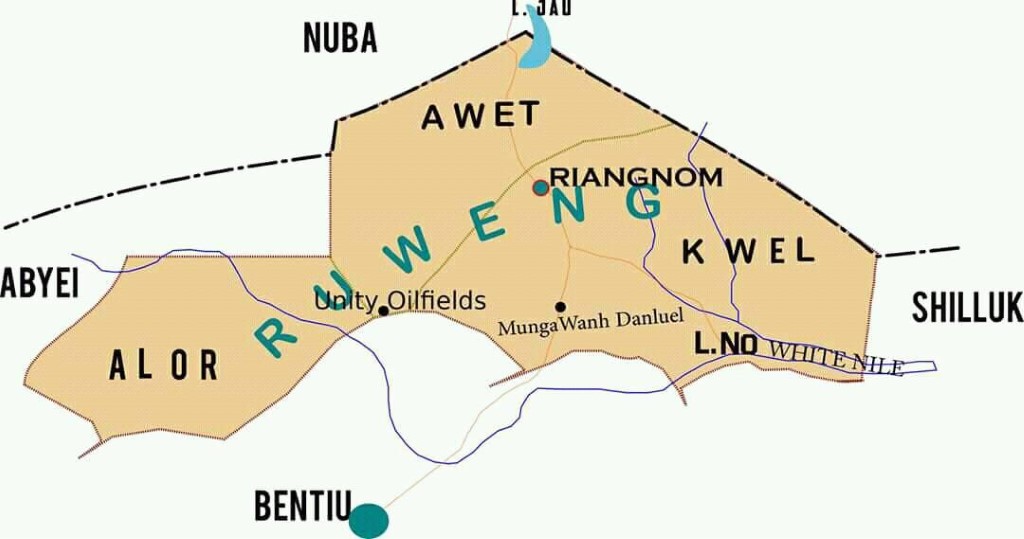
Figure 1: Boundaries of Ruweng Region Pursuant to the 1946/1956 Tribal Borders.
In short, the geographical territory of Ruweng region is clearly defined. For instance, during the final transfer of Ruweng to Upper Nile, the Sudan Government Gazette of May 15, 1931, described the northern geographical limits of the Ruweng territory in terms of latitudes and longitudes as follows:
Commencing from a point on the existing Province Boundary midway between Debba Mongok and Debba Karam Nyet (Lat. 9º 21’ Long 28º 38’) the boundary runs in an easterly direction until it meets Khor Amadgora. Thence northwards to the Bahr el Arab to the Raqaba ez Zarqa at a point ½ mile west of Tibusia, thence along the Raqaba ez Zarqa to ‘Aradeib, thence eastward along Lat. 9º 45’ to the old Kordofan–Upper Nile boundary, thence north along that boundary and continuing along the old Kordofan N.M.P. boundary to Lat. 10º 5’ marked on the map ‘Clump of Heglig’ thence N. Easterly to a point 3 miles due west of the centre of Lake Abyad [Lake Jau], thence due east to the eastern shore of the Lake, thence S.E. through the Fed Abu Finyer to the Rest House at the point where the Tonga-Talodi road crosses the Haqaba south of Abu Qussa, thence up that Raqaba to where it joins the existing Province Boundary. (See Douglas Johnson’s Note on Panthou, p.8)
According to Douglas Johnson, “this was the official provincial boundary line in effect when Sudan became independent on 1 January 1956” (See Douglas Johnson’s “Note on Panthou, “ p.8. See also Figure 2 below).
This description, however, deals solely with the northern and eastern borders of Ruweng with contemporary Sudan’s Southern Kordofan Province. That is because the southern borders of Ruweng with Nuer and Chollo (Shilluk) had already been fixed as of 1905 and reaffirmed in 1946. Figure 2 below shows the actual map which the British colonial authorities used during each transfer.
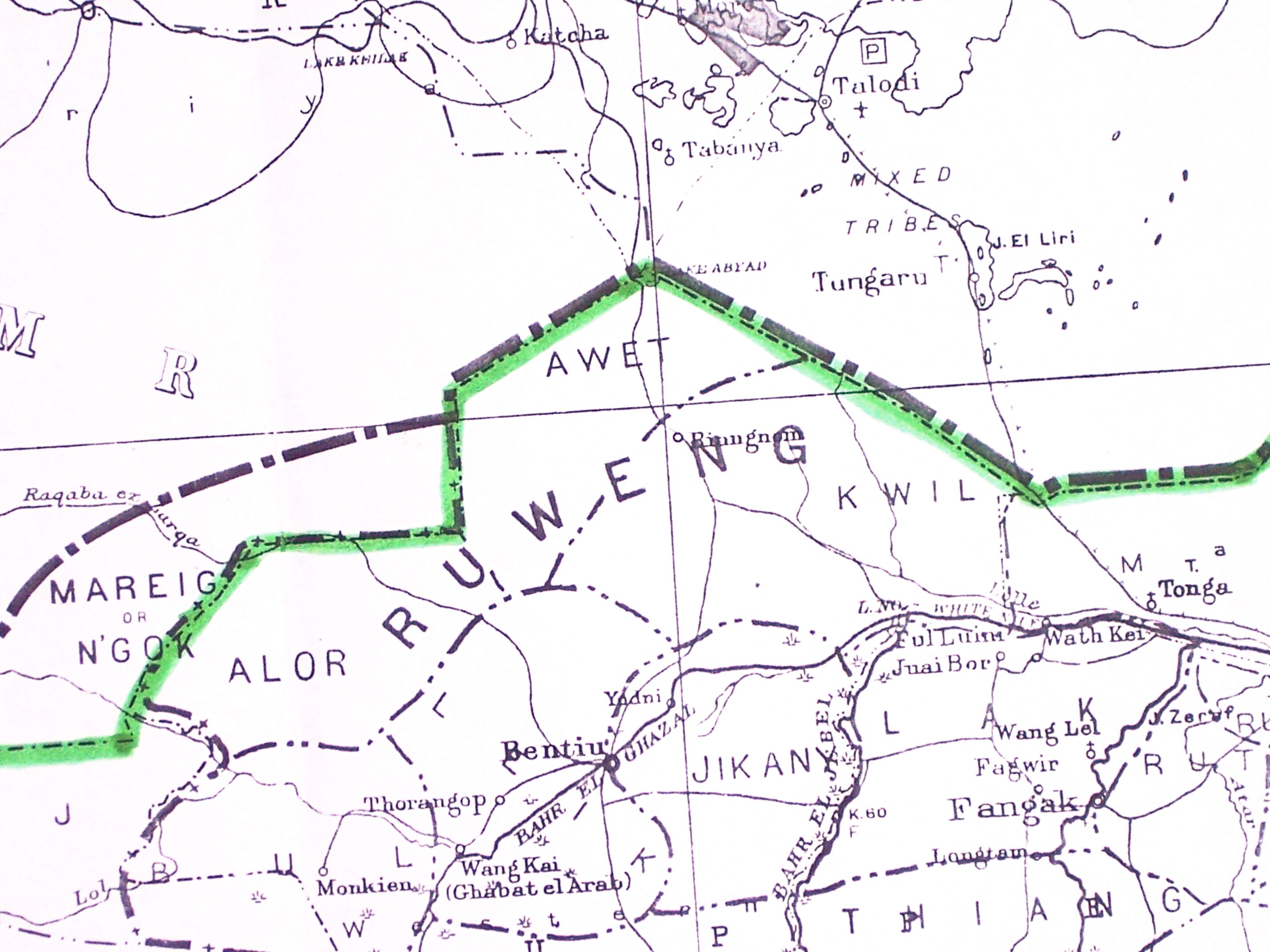
Figure 2: Ruweng Ngog Dinka sections (Sudan Survey Department, 1: 2,000,000 Sudan Tribes Sheet 3 Map, 1956). This was the map accompany every Ruweng administrative transfer to various provinces during the colonial era.
1. Is There Another Way of Defining the Boundaries Between Unity State and Ruweng Area?
There are two ways of defining communal borders in South Sudan. These are de jure borders and de facto borders.
De jure borders refer to administrative boundaries whose existence and legality are recognized and affirmed by domestic as well as by international law. In the case of South Sudan, de jure tribal boundaries are those that were delineated by the British Colonial Government on January 1, 1956, and are, therefore, the only boundaries recognized by the laws of South Sudan. In this vein, the British colonial boundaries of 1956 clearly define the borders of South Sudan including those of Ruweng and their neighbors. Their precise points are yet to be physically demarcated on the ground but we know where those borders are on the map. The legality of the 1956 tribal boundaries have been affirmed time and again by both the Government and rebel groups alike. The map below shows the borders of the Ruweng region and its neighbors. From the foregoing, one can safely conclude that, as a matter of fact and law, the Ruweng boundaries in relation to its neighbors are not only consistent with the January 1.1.1956 tribal boundaries, they also determine once and for all the geographical limits of the Ruweng region. This, legally speaking, is firmly a settled matter that Riek and Lam are trying to sabotage for their own ethnically motivated reasons.
2.2. De Facto Borders
Another way of describing Ruweng boundaries with relation to its neighbors is by way of de facto borders. These borders are captured by de facto borders.
De facto borders are administrative boundaries that describe, in theory and practice, the territorial limits of a given area/community with respect to its neighbors. De facto borders may simply be referred to as oral borders. The existence of such borders may not be in conformity with, nor necessarily recognized, by the supreme law of the land or international law. Such borders are, nevertheless, informally understood as describing the geographical limits of a given community’s territory because they allow the people/community as well as their neighbors to conduct themselves as if these boundaries were perfectly legal.
In the case of the Ruweng region and its neighbors’ borders, de facto boundaries describe:
a) The entire Ruweng territory or borders as they are, or were in fact, understood by the Ruweng community and its neighbors before or during the British occupation;
b) The way communities believed and conducted their affairs in Southern Sudan, after independence in 1956. For instance, following the Sudan’s independence from Great Britain in 1956, most road repairs in Southern Sudan were manned manually during dry seasons. In the case of Ruweng, the Kuok/Aliiny community was, for instance, responsible for road repairs all the way from Pariang to Panthou in the north and beyond Darbim (see Figure 3 below) in the south. Aniek and Diar communities were responsible for road repairs from Panyang to Kur Ajith located north of Lake Jau. In the same way, Ngeer, Bugo and Miorcigiu communities were responsible for road repairs from Pariang Town to Kubur Nyabol near Younyaang/Rubkona (shown in Figure 3 below).
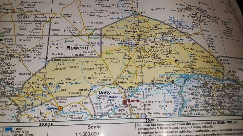
Figure 3: Ruweng Tribal Boundaries: An OCHA Map. This map does not capture all the traditional boundaries of Ruweng State. It is only here for illustrative purposes. This map was compiled by the United Nations Office of the Coordination of Humanitarian Affairs (OCHA) in South Sudan in 2007 in Juba, South Sudan.
In this regard de facto boundaries would more accurately describe the limits of Ruweng region’s borders as they were understood, both by the Ruweng people and its neighbors. That is because de facto borders have long persisted and cannot be denied by anyone or party which claims to be a credible opposition.
From the perspectives of both de jure and de facto boundaries, it should be clear that Riek’s and Lam’s assertion that the Ruweng Administrative Area has been created by annexing Nuer land is a claim founded on absolute falsehoods, manifest ethnic ill-will and political fictions. It is a claim inspired by an expansionist tendency that Riek and Lam have entertained for 30 years now.
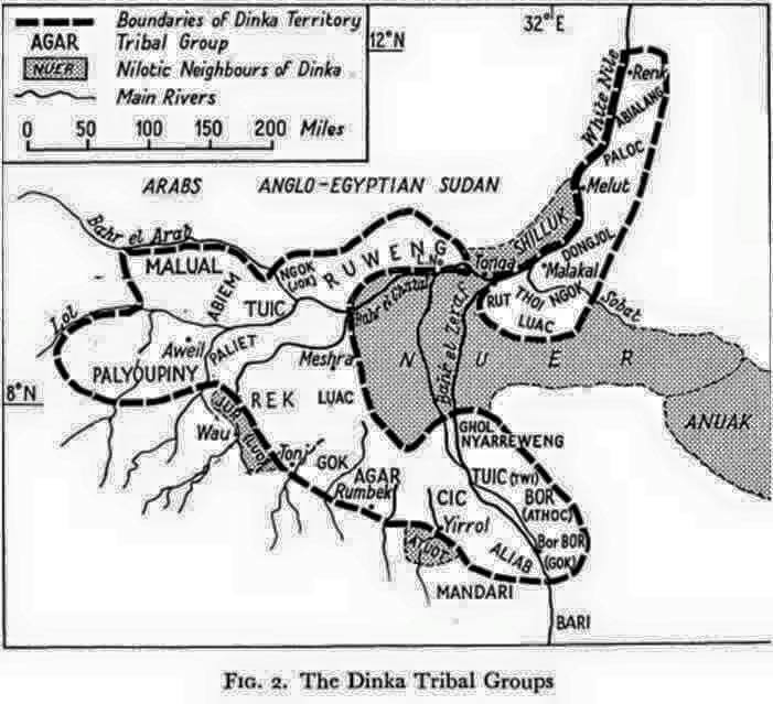
Figure 4. The Dinka Tribal Map. Taken from Godfrey Lienhardt, in Divinity and Experience, 1961.[1]
1. Moral Justifications for Creating Ruweng as a Separate Administrative Area?
Questions have been asked whether Ruweng grievances are so unique as to warrant being considered as a separate administrative area. This paper cannot purport to exhaust the litany of these grievances which go back for decades under none other than Riek and Taban Deang Gai. The following sections only seek to underscore the fact that Ruweng (a) has historically been an administrative unit; (b) has suffered invidious marginalization in Unity State and; (c) was subject to willful depopulation by Riek Machar, Taban Deang Gai and their allied forces in order to claim Ruweng land.
1.1. Ruweng as an Independent Administrative Structure in the 1990s
During the war of liberation (1983 to 2005), the Ruweng Ngog Dinka was among communities that disproportionately contributed manpower to the struggle. It was also one of the communities that were largely affected by internecine wars. These started when the same figures namely; Riek Machar, Lam Akol and other senior military officers of the Sudan People Liberation Army (SPLA) staged a coup against the SPLA in 1991. These serial rebel leaders pivoted their violent campaigns on human rights violations and what they called Chairman Garang’s dictatorship. These are the same two issues that they still bank on today to justify their armed rebellions against President Kiir. Following their failed coup attempt in 1991, both Riek and Lam embarked on an ethnically targeted mayhem that saw the entire Upper Nile region go up in flames. For quite some time, their forces managed to control much of Upper Nile region (including Bor) except Ruweng and Pigi, in northern Jonglei area. Under the leadership of Commander Mayiik Jaw, the Ruweng forces, with the support of their youths, fought long and difficult wars. They held their ground against the combined forces of Riek Machar, Lam Akol, and the Enemy from Khartoum until the Comprehensive Peace Agreement (CPA) was signed in 2005. From the time they staged their Nasir Coup until 2001, Riek’s forces in particular (sometime supported by Matib NHial and Arab militias) embarked on the mission of exterminating the entire Ruweng Ngog Dinka.
As a consequence, what ensued in the next 14 years (from 1991 to 2005) was an administrative transfer of Ruweng to Nuba Mountains. For some founded and legitimate reasons, an independent Ruweng administrative area was late created, separate from Western Upper Nile which was named as Unity State in 1994. It was called the Pariang Independent Brigade and its military radio was called The Winner in light of Ruweng’s resilience and successful resistance against the combined genocidal forces of Riek, Bashir and their allied militias. Since then, Ruweng conducted its own affairs entirely separate and independent from Unity region. It stands to reason that the creation of a separate administrative structure for the Ruweng Ngog Jieeng (Dinka) of Pariang and Abiemnhom is firmly anchored in the history and struggle of the South Sudanese people.
1.1.The Politics of Marginalization and Exclusion in Unity/Western Upper Nile State
Another basis for justifying a separate administrative unit for the Ruweng region organically arises from the long chain of willful marginalization of the Ruweng people by successive Nuer leadership that has come and gone from Bentiu. This marginalization prompted the Ruweng Ngog Dinka to call for a separate administrative structure from Unity State as early as 2009. Several petitions, some of which were open letters and are still available online, can attest to the endurance of this demand. In order to appreciate the reasons for these petitions, one has to gain deeper insights into the essence of the toxic relations between Ruweng and Nuer in the region.
To begin with, the government of Unity State was a government that served the interest of the Nuer, much to the exclusion the Ruweng Ngog Dinka which made up more than 22% the state population. Although the 2008 Census did not consider ethnic numerical strengths and was not accurate in several respects, most counties, except Rubkona and Mayom (the two that had very large number of mixed inhabitants and included the numbers of military forces in their numbers), were almost 100% ethnic Nuer or Jieeng.
Generally, however, governance in the Old Unity State was practically aimed at excluding the Dinka. For instance, in its Preamble, the Unity State’s Transitional Constitution declared that “Unity State and all its territories are Western Nuer Land.” This is akin to declaring that “South Sudan is a Dinka Republic.” Such a preambular declaration translated into practical programs on the ground. These, for instance, include the fact that (a) the government was run by Nuer for the Nuer; (b) Dinka language was banned from being broadcast over the radio (because the State was exclusively meant for the Nuer), (c) parliamentary sessions were largely conducted in Nuer; (d) no single Dinka student, not even one, was ever given scholarship at the state level in a state that offered hundreds of scholarships to Nuer students; (e) knowledge of the Nuer Language was a requirement for lending state jobs; (e) policies that denied health services to Ruweng on account of their ethnic identity were in operation; (f) using the state apparatus (such as the police and military) to forcefully occupy the Dinka land (Nuer had the right to claim and effectively occupy Ruweng Ngog Dinka Land, claiming that the Dinkas are only guests in the State and can only enjoy the right to land or dignified existence at the pleasure of the Nuer: almost all positions in police service, wildlife, security services etc., within Ruweng areas were occupied by Nuer, just Payam Administrators in Ruweng land were often deputized by Nuer. The intent and purpose of all this was to effectively make the Ruweng people live under the tutelage of Nuer. They were also forms of cultural assimilation and invidious discrimination and deprivation in practice.
These examples are just a tip of the iceberg. What happened prior to 2005 was even graver.
1.1. The Genocides of the 1990s
What was happening in the Old Unity State until 2013 was a stark reminder of the genocidal campaigns waged against the Ruweng, genocides that were principally originated and masterminded by Riek Machar and Taban Deang Gai from mid 1980s forward. These violent campaigns peaked in the 1990s. For instance, when the kala azar pandemic broke out in the region in the mid1980s, an outbreak which eventually wiped out more than almost 30% of the resident Ruweng population at the time, Riek Machar, willfully and pitilessly decided to locate all the kala-azar treatment clinics in Nuer land, several hundred kilometers south from Pariang. This happened in his capacity as Zonal Commander at the time. Several petitions for mobile clinical services to Ruweng were denied. This invidious genocidal policy resulted not just in the death of 30% of the Ruweng population. It was also true that thousands of Ruweng survivors who managed to reach those clinics on foot from Pariang were butchered in their hospital beds when Riek staged his coup in 1991. Rieks’ and Taban’s long term plans were to depopulate Ruweng so that they can easily claim and occupy Ruweng land as they have done over the course of the last one and half decades.
As can be attested to by many independent observers today, Ruweng is the poorest region in this country despite the fact that 85% of oil produced in all territories of former Unity State comes from oil wells located in Ruweng land. These wells include (please the Figures 1 and 3 above) Unity (Darbim) Oilfields, Munga (Adongloj/Wanhdanluel) Oilfields, Lalob (Miading) Oilfields, Toma South (Kaloj) Oilfields and el Toor (Athony Oilfields), Man-Awal Oilfields, among others. Yet the level of poverty and indignities that meets one’s eyes as one tours Ruweng was not by a happenstance. It was politically induced by both Riek and Taban and their countless accomplices and accessories.
Would anyone want to subject the Ruweng region and its people to a state of perpetual poverty, forceful displacement from their land, lack of services such as schools, medical services, and all other forms of inhuman treatment that these people have had to endure in the last three decades?
1.Conclusion
Riek Machar’s vigorous opposition to 32 states was not because he did not want to support more states. The idea of more states was, in fact, entirely his own engineering. What undergirded his opposition to 32 states was, however, the creation of a separate administrative structure for Ruweng. That is because separating a Ruweng administration from his own ethnic bastion operates to stifle his expansionist policy and dream of creating a monolithic Nuer empire in the Unity region and beyond. His conduct in the past 30 years is clearly demonstrable of his manifest intent to achieve this at the expense of the Ruweng Ngok Jieeng people.
His declaration that the establishment of the Ruweng Administrative Area (RAA) opens a Pandora’s box is clearly a threat of the use of violence to force compliance. Furthermore, his unfounded claim that the RAA has been created by annexing Nuer land is not only a lame justification for his opposition to Ruweng. It also shows his true color as a champion of Nuer interest and expansionist policy at the expense of Ruweng. This policy is made clearer not only in the preambular declaration in the former Unity State’s Transitional Constitution which states to the effect that all the territories of Unity State are part of Western Nuer Land. It is also clearer in a series of practice that involves denying Ruweng people the right to participate in the political process in former Unity State, the right to speak their language, right to employment or jobs and other opportunities including provision of essential services such as education, basic healthcare, physical security, among others. In addition, the right of the Ruweng people to live a dignified existence in their own land and run their own affairs is something not only ordained by international law but also by the law of nature.
RAA welcomes all people from any corner of this country to make Ruweng their home and state. Any citizen who chooses to settle in Ruweng or make Ruweng his or her habitual residence, whether he or she is from Nimule, Nasir, Raja or Boma, is welcome. That is because from the perspective of our own laws and Transitional Constitution, any South Sudanese citizen is entitled to live, work and even run for an elected office anywhere in South Sudan. It stands to reason that if one chooses to live in Ruweng permanently, he or she is entitled to all civil, political and economic rights as a native born RAA citizen. But any forceful attempt to occupy Ruweng land or annex it or refer to the Ruweng people as guests in their own land (which many people and the Transitional Constitution of the former Unity State claim to be a Nuer land) is to violate the human rights of the Ruweng people. Such a mindset will be resisted at any and all costs.
Finally, if Riek truly believes that his claim about Nuer land having been annexed to RAA is a position supported in fact and law, then the most civilized way of dealing with such a grievance is to lodge a claim for adjudication (a) before the Supreme of South Sudan or any other court of competent jurisdiction within the Republic of South Sudan; (b) at the East African Community Court; or (c) in the event that all local remedies have been exhausted, he can lodge a case with an international tribunal. However, threats of war should be avoided. Riek should be cognizant of the fact that the threat or use of violence goes either way. No single individual or community has an absolute monopoly over the use or threat of violence. If by all means Riek does not believe in any civilized process of dealing with grievances and land disputes and continues, instead, to threaten Ruweng, then the choice for war and violence or for peace is entirely in his personal domain. He can choose one or the other. But he needs to be reminded that luck has limits. In addition, if Lam Akol (Riek’s ideological soulmate) chooses whatever Riek chooses, he is also entitled to exercise that discretion. We know for a fact that whatever Riek does, Lam does it better because he has a larger brain. Whatever they choose to do, I am sure of one thing: an amoral politics ends in disgrace. The end of their political maneuvering which they have tactically deployed for 30 years is clearly well-nigh.
Santino Ayuel Longar, Ph.D., is an Assistant Professor of Law at the University of Juba’s College of Law. He can be reached at ayuelongar@gmail.com or 14sd23@queensu.ca
[1] See Godfrey Lienhardt, Divinity and Experience: The Religion of the Dinka (Oxford: OUP, 1961) at 8.
The views expressed in ‘opinion’ articles published by Radio Tamazuj are solely those of the writer. The veracity of any claims made are the responsibility of the author, not Radio Tamazuj
 and then