


Subject: Clarification on the Misstatement Concerning the Kapoeta East County Border Alignment with Uganda
From: Aldo Lokonyen Ben,
Concerned citizen, Budi County, Republic of South Sudan.
Your Excellency,
With due respect and patriotic concern, I write as a citizen of Budi County to address a recent public statement attributed to the commissioner of Kapoeta East County, in which he reportedly claimed that Kapoeta East shares a direct border with Uganda.
This statement is historically inaccurate, geographically misleading, and inconsistent with the officially recognized boundaries of Eastern Equatoria State. Such claims risk confusing the public, distorting administrative records, and undermining the historical integrity of our county boundaries.
1. Historical and Legal Foundation
The territorial boundaries of the Republic of South Sudan are grounded in the 1 January 1956 line, inherited from the Anglo-Egyptian Condominium and reaffirmed upon independence in 2011. This boundary remains the principal legal framework for defining both internal and international borders.
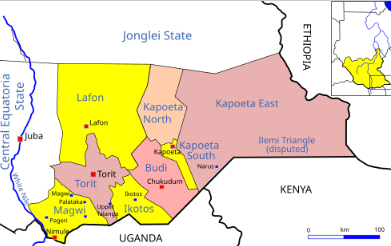
According to the Sudan Survey Department maps of 1931, 1944, and 1953, as well as documentation used by the Sudan–South Sudan Boundary Commission, the international border with Uganda runs along Budi County—specifically through the Ilimi Triangle and the Narus–Nadapal–Lotukei corridor. Historically, this area was administered under the Lotukei and Chukudum divisions of Eastern Equatoria Province.
By contrast, Kapoeta East County lies farther east, sharing borders with Kenya to the south, Ethiopia to the east, Jonglei State to the north, and Budi County to the west. At no point—historically or administratively—has Kapoeta East County shared a boundary with Uganda
2. Contemporary Cartographic and Institutional Evidence
This established demarcation is further confirmed by credible modern references, including:
• The United Nations OCHA County Reference Map (2020), which places Kapoeta East’s southern boundary exclusively along Kenya;
• The UNHCR South Sudan–Kenya Border Mapping Project (2013), confirming Kapoeta East’s adjacency only to Kenya and Ethiopia;
• The Conflict Sensitivity Resource Facility (CSRF) County Profiles (2018) and the Administrative Map of Eastern Equatoria, both of which list Magwi, Ikotos, and Budi Counties as South Sudan’s only border counties with Uganda; and
• The Social Science in Action Report (2022) titled “Cross-Border Dynamics Between Uganda and South Sudan”, which again identifies only Magwi, Ikotos, and Budi as the Uganda-bordering counties.
Collectively, these authoritative sources affirm that Budi County, not Kapoeta East, forms South Sudan’s legitimate border with Uganda and Kenya along the Ilimi Triangle.
3. Call for Rectification
Your Excellency, while the Commissioner’s remarks may have been made without ill intent, such misinformation risks:
• Creating administrative confusion between counties;
• Misrepresenting historical and legal facts to the public; and
• Undermining regional cooperation and peaceful coexistence among neighboring communities.
I therefore respectfully urge your esteemed office to:
1. Issue a public clarification reaffirming the correct border delineation in accordance with the 1956 reference line; and
2. Advise county leaders and administrators to ensure that future public statements are consistent with verified historical and legal records.
4. Conclusion
Borders define more than geography—they embody our shared history, identity, and administrative integrity. Upholding their accuracy is a matter of national responsibility and civic truth.
I remain confident that under your wise leadership, the Government of Eastern Equatoria State will act decisively to preserve historical accuracy, strengthen inter-county unity, and safeguard peaceful coexistence among our people.
With highest esteem and patriotic regards,
Aldo Lokonyen Ben
Concerned Citizen, Budi County
Cc:
• Hon. Commissioner, Budi County
• Hon. Commissioner, Kapoeta East County
• State Ministry of Local Government & Law Enforcement
• Ministry of Lands, Housing & Urban Development, Juba
• State Security Office, Eastern Equatoria

 and then